RANGOON — In order to get a sight of their city’s river, residents of Burma’s commercial capital currently cram into a few jetties where they can take morning exercise or evening walks. But soon, they may have more space.
That is if the city’s committee working on urban planning gets its way.
During a public forum Tuesday, Rangoon’s Comprehensive Land Use, Zoning and Urban Design Review Working Committee proposed that a public space along Rangoon’s riverfront be created to improve quality of life for residents.
Committee member Hlaing Maw Oo, director of the Ministry of Construction, said that most of the area along the city’s Hlaing River, also known as the Rangoon River, should be designated as “green space” and called for at least 25 feet (8 meters) of space along the waterfront to be reserved for public recreation.
“We don’t ask very much, just at least 25 feet for the public,” she said.
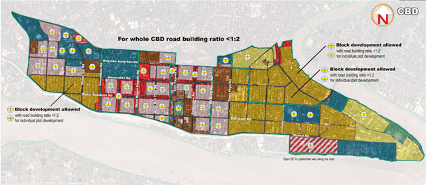
According to a map distributed at the public forum, a strip of the riverfront at least three-miles long is proposed as a “Green and Blue Zone,” punctuated with smaller areas demarcated for “waterfront special development.” In most of the development zones along the river, buildings up to three stories high will be permitted, as long as the view of the Shwedagon Pagoda from the river is preserved.
“It’s a big step forward,” said Thant Myint-U, founder of the Yangon Heritage Trust (YHT), noting that the Burma government has never consulted the public on such decisions in the past.
“Our main idea is to let people have as much access as possible to the waterfront area,” he said. At present access to the river is limited to the Pansodan and Botahtaung jetties, which have become popular hangouts for locals.
Initiated by Yangon City Development Committee (YCDC), Rangoon’s municipal body, the working committee has been discussing its plan for land use and zoning for a year.
The working committee was approved by the city’s mayor and is made up of ten experts from YCDC, the Ministry of Construction’s department of human settlements and housing development, YHT, Mandalay Technological University, the Association of Myanmar Architects (AMA) and the Japan International Cooperation Agency (JICA).
According to the proposed land-use and building height zoning plan, Rangoon will have 11 types of “zone,” each with their own respective restrictions on the height to which new buildings can be constructed.
For example, in 19 “Mixed Use” zones in the downtown area (between Lanmadaw Road and Theinbyu Road)—which have both commercial and residential buildings—new developments will be restricted to six stories.
Some areas just north of the central business district will a 16 stories, while in areas along Prome Road buildings up to 20 stories will be allowed.
In other “heritage zones,” in particular areas of downtown containing colonial-era architecture, construction will be even more restricted.
In the vicinity of the Shwedagon Pagoda, building heights will be restricted to between 62 and 78 feet, while in nearby areas toward downtown, buildings must be less than 190 feet.
“We will use this plan when we consider whether to allow high-rise buildings or not,” said Toe Aung, deputy head of YCDC’s city planning and land administration department. “But for the time being, we have to wait for public feedback on the plan.”
He said the committee will wait about a month for suggestions from the public before it submits the plan to the Rangoon Division Government for approval.


